
SMALLMOUTH HUNTER
Terry Dodge | Owner
Blinded Veteran | USMC/BVA/NBVO


Terry Dodge
KISHWAUKEE RIVER REC


BE SAFE & ENJOY
This page shows the latest values for the stretch flowing from Cherry Valley down stream to the Rock River
Normal Summer Time Flow is 5.75ft. @ 390cfs
READING THE GAGE: (Following the blue-line) The most recent reading on the, Gage height, feet graph, is on the far righthand side at the end of the blue-line. The river heights are displayed virtually on the left hand side of graph. Once the height of the river is determined, match that reading with the Caution Banners displayed above. NOTE: If the USGS graphs are not displaying below, please click the USGS Direct Link that is provided.

This page is undergoing modernization with expected decommissioning as key features are added to the modernized pages. Please follow the provided direct link to USGS Monitoring location:
Kishwaukee River Near Perryville, IL - USGS-05440000
Like Us On Facebook
For the Best & Latest information on Kishwaukee river conditions.
FB Cover photo is adjusted as needed to show the current status of the river level and a recommended level guide to go by.
Enjoy the latest edition of the
Kishwaukee Valley Newsletter

(Click image to view)
Cautions | Info | Tips
CAUTIONS | SAFETY TIPS | INFO
Always watch for and stay clear of strainers

Thanks to our Sponsors

Kishwaukee River Rec would like to thank the Illinois Smallmouth Alliance for it's sponsorship and support.

KRR River Sack Kit
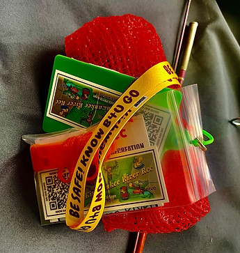
Kishwaukee River Rec River Sack Kit:
1- 22" x 24" River Cleanup Trash Sack
1 - KRR Lanyard
1 - KRR Kayak Sticker
1 - Safety Whistle
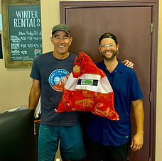
Available at Rocktown Adventures
Tell Kevin and Travis you LIKE Kishwaukee River Rec
KRR Kayak Sticker
